The trail was photographed on the same day by the same photographer
 Click for a larger image
 The "Guardian of the Hills" statue indicated on the sign, where the route begins and ends, is depicted on this sign
 Click for sign's details
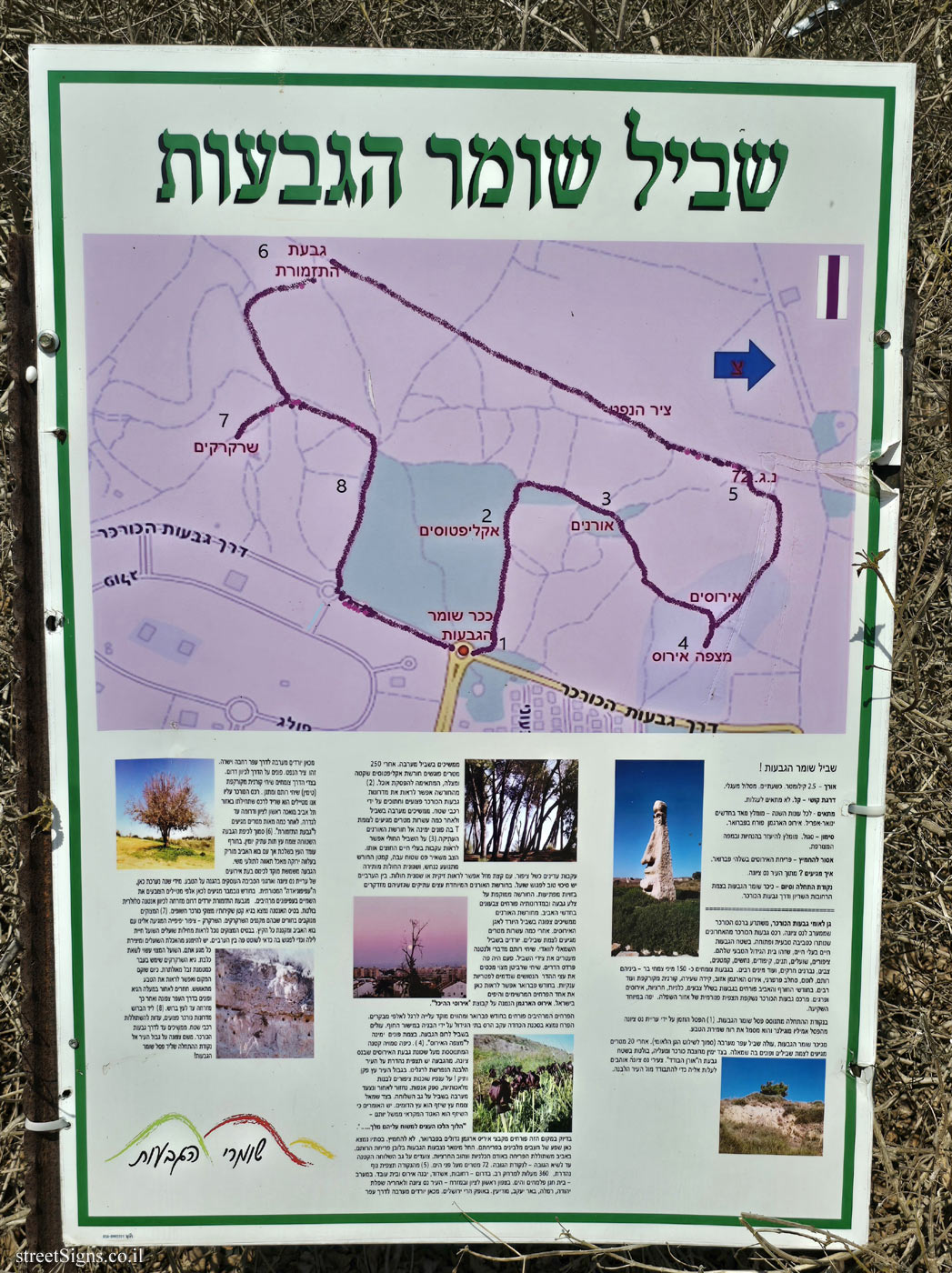
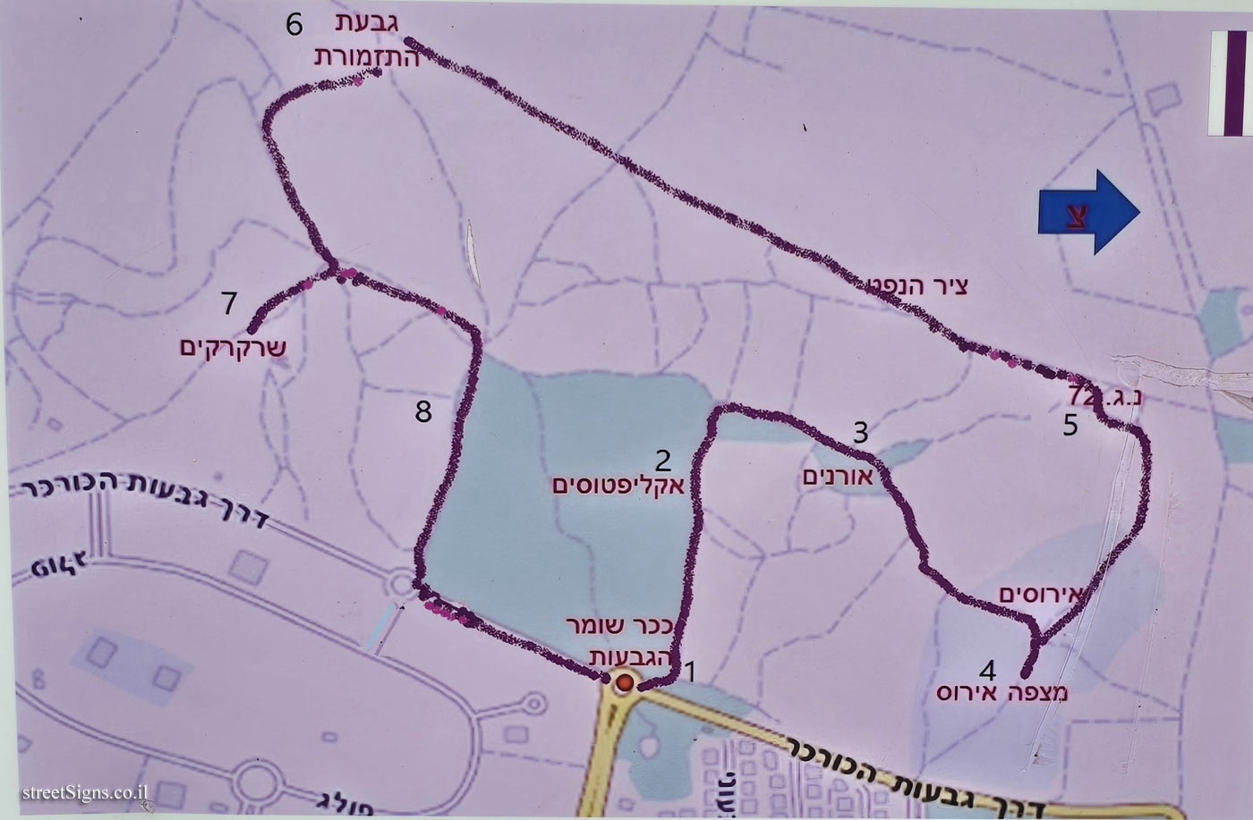
 The numbers indicated on the sign are indicated on the map that appears at the top of the sign. Here is the map at magnification
 Click for a larger image Translation of the text on the sign
:
The Hill Guard Trail [trail map]
The hill guard trail!
Length - 2.5 kilometers. about two hours circular route.
Difficulty level - easy. Not suitable for strollers.
Suitable - for all seasons - highly recommended in January-April. The crimson iris blooms in February.
Marking - purple. It is recommended to use the instructions and the attached map.
Not to be missed - the flowering of irises at the end of February.
How do you arrive? From the city of Nes Ziona.
Start and end point - Shumer Givat Square at the intersection of Hasharion Streets and Givat HaKurkar Road.
[Photo: "Guardian of the Hills" statue]
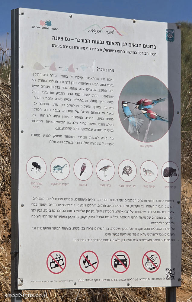
HaKorkar Hills National Park, extends in the HaKorkar ridge to the west of Nes Ziona. The Korkar hill range is one of the last remaining natural and open environments. Animals live in the hills, which is their natural habitat. Birds, foxes, jackals, hedgehogs, snakes, wrens, turtles, gnats, insects, and many other species. About 150 species of wild plants grow in the hills - among them Rotem, Cistus , butterfly orchid, scarlet iris moss, hairy bow, scalped thyme and many more. In the winter and spring months, anemones, chrysanthemums, irises and poppies bloom in the hills in many colors. A panoramic view of the lowland area can be seen from the ridge of the Kurkar hills. The sunset is especially beautiful.
At the starting point stands the statue of the guardian of the hills. (1) The statue was commissioned by the Nes Ziona Municipality from the sculptor Emilio Mogilner and it symbolizes the spirit of preserving nature.
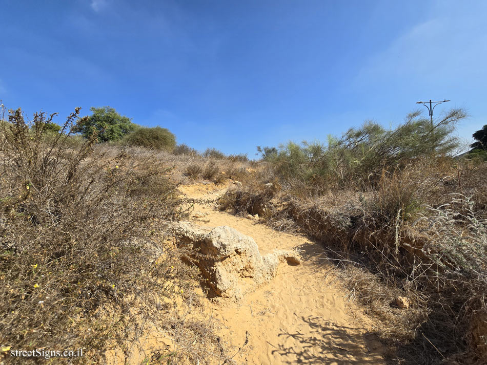
A dirt path goes west from Shomer Givat Square (near the National Park signage). After 20 meters you reach a trail junction and turn left at it. On the right is the Kurkar Quarry and above it, stands out in the area of the "Lonely Pine" hill. The young people of Nes Ziona like to go up to it to be alone in front of the White City.
[the hill picture]
Continue along the west path. After 250 meters you meet a quiet and shady eucalyptus grove, suitable for a lunch break. (2)
From the grove you can see the slopes of the Kurkar hills scarred and cut by off-road vehicles. Continue west on the path and after a few tens of meters you reach an intersection where you turn right into the ancient pine grove. (3)
On the sandy path you can see animal tracks crossing it. The turtle leaves a thick flat stripe, the Sheltopusik moves like a snake, and the Nidua fringe-fingered lizard leaves delicate tracks like a bird. With a little luck you can see a chameleon or a Sheltopusik. In the evening there is a good chance to meet a fox. In the special pine grove there are ancient trees whose trunks stick out at surprising angles. The grove is located on the side of a hill and on its slopes tulips bloom in the spring months. From the pine grove continue north on the path that descends to the engagement basin. After a few tens of meters you reach a trail junction. Go down the left path to Wadi. Retama raetam and lantana decorate the sides of the path. There used to be a citrus orchard here. Common Ephedra bushes cover the abandoned citrus trees that resemble giant mushrooms. In February you can see here one of the most impressive and beautiful flowers in Israel. The Scarlet Iris is part of the "Temple Engagements" group.
[Photos of the groves]
The magnificent flowers bloom in the month of February and are a focus of pilgrimage for thousands of visitors. The flower is in danger of extinction due to habitat destruction by construction on the coastal plain. Go up the path to the top of the hill. At the intersection turn right to "Mitzpe Iris". (4). A small hidden dome towering over the Givat HaIrusim neighborhood in Nes Ziona. From the hill there is a great view of the White City spread out at our feet. An old pecan tree at the border of the city! Artificial white birds, probably herons, perch on its branches. We will go back and walk west on the path on the back of the spur. On the left side grows a jujube tree is a similar tree. Some say that the jujube is the biblical Lycium from the the Jotham parable -
"The trees went forth on a time to anoint a king over them... ..."
[Photo: The Crimson Iris]
In this very place, large clusters of crimson irises bloom in February, not to be missed. In the fall there is an abundance of bleaching stones in their blooms. Starting in January, the hills are colored with the whiteness of the blossoming of the lotus flowers. In the spring, the blooming is rampant in the red of the anemones and the yellow of the chrysanthemums. Walk on the back of the small extension to the height peak - the high point. 72 meters above sea level. (5) From the point a great view, 360 degrees for a long distance. In the south - Rehovot, Ashdod, Yavne Iris and Beit Oved. In the west - Beit Hanan Palmahim and the sea. In the north of Rishon Lezion and in the east - the city of Nes Ziona, followed by the Yehuda Plain, Ramla, Beer Ya’akov, Modi’in. On the horizon are the Jerusalem mountains. From here you go west to a wide and straight dirt road. This is the oil axis. Turn on the road to the south. On the sides of the road grow bushes of scalped thyme (thyme), Rotem and Tannan bushes. The Kurkar Ridge on which we are traveling is a remnant of the ridge that begins in the Tel Aviv area at Rishon LeZion and south to Gedera. After a few hundred meters you reach the "Orchestral Hill". (6) Near the top of the flat hill grows an ancient mulberry tree. In winter, the tree is dormant, but with the coming of spring, turns green with green foliage that silkworms crave.
[Image: Mulberry Tree]
The hill is used as a meeting point during events of the municipality of Nes Ziona and the environmental organizations involved in the protection of nature. Every year, the traditional "Kite Parade" is held here. In the month of November, thousands of travelers come here to paint the sky with spectacular kites. From the orchestra hill, go down southeast towards a prominent cellular antenna. The base of the antenna is in a small ravine whose walls are exposed karkar cliffs. (7)
[Photo: The Kurkar Cliffs]
The cliffs are pierced with holes where the crickets nest. The buzzard - a beautiful bird that comes to us with the arrival of spring and nests all summer. At the base of the cliffs we can see fox dens. The fox is a nocturnal animal and to meet it you should wander here between evenings. Avoid feeding the foxes and making any contact with them. The common fox may carry rabies. The bee-eaters ravine used to be used as a makeshift garbage dump. Today the place is being restored and you can see nature recovering. Go back up the ravine and turn on the dirt road to the north and then east to a cypress tree. (8) Near the cypress are wounded Kurkar slopes, evidence of off-road vehicle rampage. Continue up to the road to the Kurkar Hills. From there north on the city border to the starting point next to the statue of the Guardian of the Hills!
[Hill Guards Symbol]