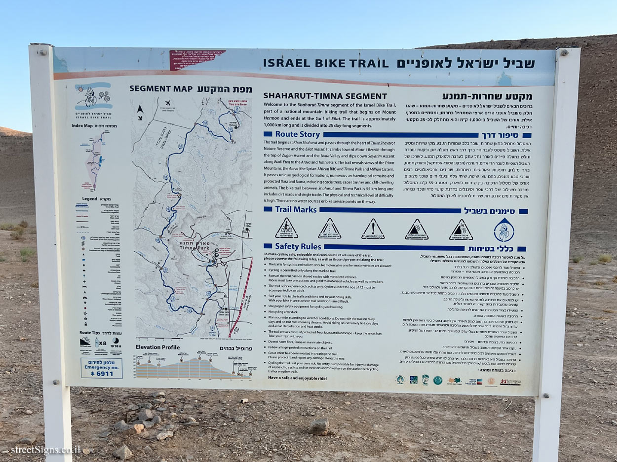
On the sign:
שביל ישראל לאופניים
ISRAEL BIKE TRAIL
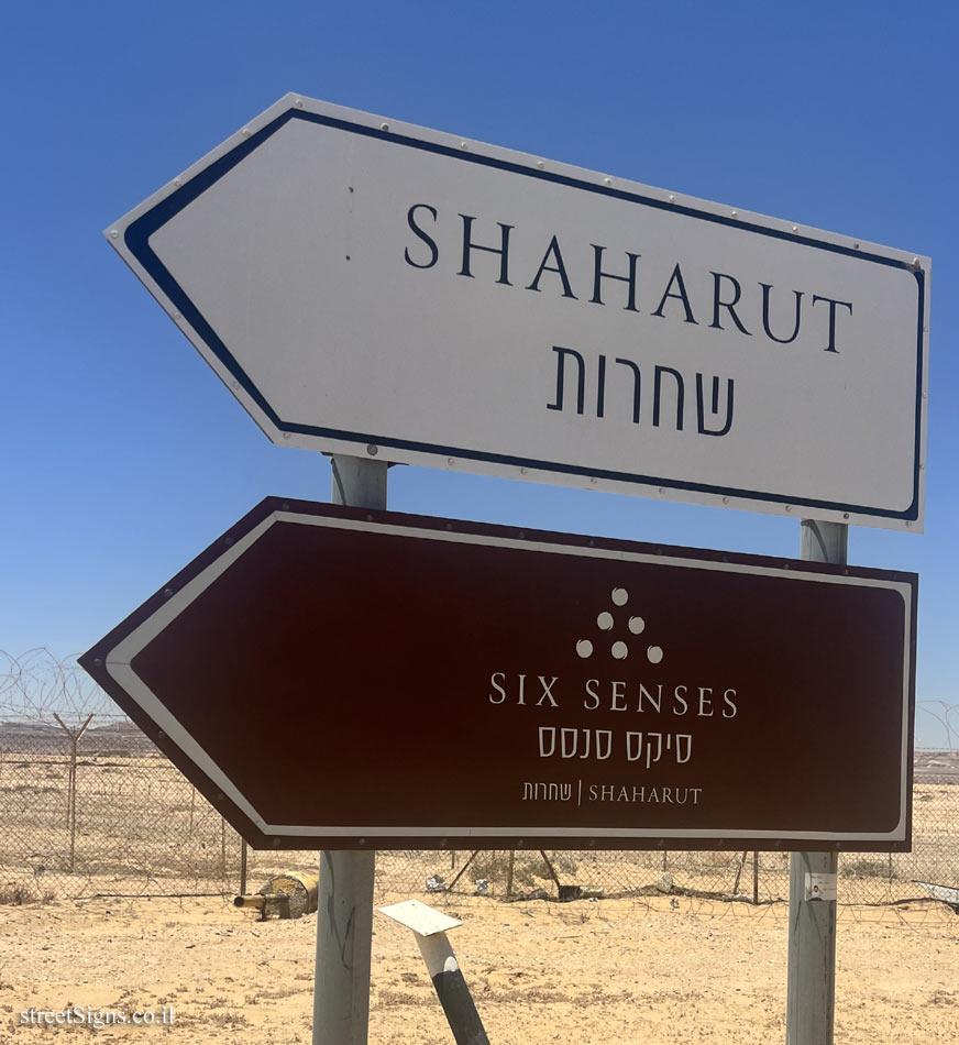
מקטע שחרות-תמנע
ברוכים הבאים לשביל ישראל לאופניים - מקטע שחרות-תמנע - שהנו חלק משביל אופני הרים ארצי המתחיל בחרמון ומסתיים במפרץ אילת. אורכו של השביל כ-1,000 ק"מ והוא מתחלק לכ-25 מקטעי רכיבה יומיים.
סיפור דרך
המסלול מתחיל בחאן שחרות ועובר בלב שמורות הטבע צוקי שיירות ומסיב אילת. השביל מטפס לעבר הר ברך דרך ראש מעלה זוגן ובקעת עובדה וגולש במעלה סיירים לאורך נחל עתק לערבה ולפארק תמנע. לאורכו של השביל תצפיות לעבר הרי אדום, הערבה (הבקע הסורי-אפריקאי) ופארק תמנע, באר מילחן, תופעות גאולוגיות מיוחדות, שרידים ארכיאולוגיים רבים וערכי טבע מוגנים, בהם עצי שיטה, שיחי צלף ובעלי חיים שוכני מצוקים. אורכו של מסלול הרכיבה בין שחרות לפארק תמנע כ-55 ק"מ. המסלול מורכב משילוב של דרכי עפר וסינגלים בדרגת קושי פיזי וטכני גבוהה. אין מקורות מים או נקודות שירות לרוכבים לאורך המסלול.
סימנים בשביל [אייקונים של סימון השביל, ואזהרות מפני סכנות שונות]
כללי בטיחות
על מנת לאפשר רכיבה בטוחה ומהנה, המתחשבת בכל משתמשי השביל, אנא הקפידו על הכללים האלה והישמשו להנחיות השילוט בשביל:
• השביל נועד לרוכבי אופניים ולהולכי רגל בלבד. הכניסה באופנועים או ברכב מנועי אחר - אסורה!
• הרכיבה מותרת אך ורק בשביל האופניים המסומן בשטח.
• חלקים מהשביל עוברים בדרכים המשותפות לרכב מנועי. יש לרכוב במשנה זהירות ולתת זכות קדימה לרכב מנועי ולהולכי רגל.
• השביל נועד לרוכבים מיומנים ומנוסים בלבד, רוכבים מתחת לגיל 12 חייבים ליווי מבוגר.
• יש להתאים את הרכיבה לתנאי השטח וליכולת הרוכב. קטעים שהעבירות בהם קשה יש לעבור רגלית,
• הצטיידו בציוד הבטיחות המתאים לרכיבה ולהליכה.
• הרכיבה בשעות החשכה אסורה.
• יש לתכנן את הרכיבה בהתאם למזג האוויר: אין לרכוב בשביל בימי גשם ואין לחצות ערוצי נחל זורמים. בימי שרב יש להימנע מרכיבה ולהישמר מהתייבשות וממכת חום.
• השביל עובר באזורים שמורים בעלי ערכי טבע ונוף מיוחדים - שמרו על הניקיון. קחו את האשפה עמכם.
• הפגיעה בחי, בצומח ובדומם - אסורה!
• עקבו אחר השילוט המוצב בשביל והישמעו להוראותיו.
• בשביל הושקעו מאמצים רבים להסדרתו לרכיבה, אנא שמרו עליו ודווחו על מפגעים לאורכו.
• הרכיבה בשביל היא באחריות הרוכב בלבד. אף גורם לא יהיה אחראי לכל פגיעה ונזק שייגרמו לרוכב ו/או לנוסע ו/או להולך רגל בשביל שבו הותרה הרכיבה או בשבילים אחרים.
רכיבה בטוחה ומהנה!
[סמל משרד התיירות]
[סמל החברה הממשלתית לתיירות]
[סמל המשרד לפיתוח הנגב והגליל]
[סמל המשרד להגנת הסביבה]
[סמל משרד החקלאות וטיפוח הכפר]
[סמל חבל אילות]
[סמל קרן קיימת לישראל]
[סמל רשות הטבע והגנים]
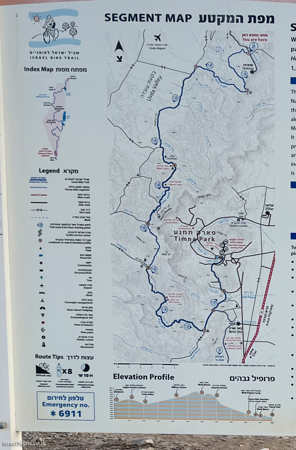
[מפת המקטע]
SHAHARUT-TIMNA SEGMENT
Welcome to the Shaharut-Timna segment of the Israel Bike Trail, part of a national mountain biking trail that begins on Mount Hermon and ends at the Gulf of Eilat. The trail is approximately 1,000 km long and is divided into 25 day-long segments.
Route Story
The trail begins at Khan Shaharut and passes through the heart of Tsuke Shayarot Nature Reserve and the Eilat massif. It climbs toward Mount Berekh through the top of Zugan Ascent and the Uvda Valley and dips down Sayarim Ascent along Wadi Eteq to the Arava and Timna Park. The trail reveals views of the Edom Mountains, the Arava (the Syrian-African Rift) and Timna Park and Milhan Cistern. It passes unique geological formations, numerous archaeological remains and protected flora and fauna, including acacia trees, caper bushes and cliff-dwelling animals. The bike trail between Shaharut and Timna Park is 55 km long and includes dirt roads and single tracks. The physical and technical level of difficulty is high. There are water sources or bike service points on the way.
Trail Marks [icons of trail markings, and warnings of various dangers]
Safety Rules
To make cycling safe, enjoyable and considerate of all users of the trail, please observe the following rules, as well as those sign-posted along the trail:
• The trail is for cyclists and walkers only. No motorcyles or other motor vehicles are allowed!
• Cycling is permitted only along the marked trail.
• Parts of the trail pass on shared routes with motorized vehicles. Riders must take precautions and yield to motorized vehicles as well as to walkers.
• The trail is for experienced cyclists only. Cyclists under the age of 12 must be accompanied by an adult.
• Suit your ride to the trail conditions and to your riding skills. Walk your bike in areas where trail conditions are difficult.
• Use proper safety equipment for cycling and walking.
• No cycling after dark.
• Plan your ride according to weather conditions: Do not ride the trail on rainy days and do not cross flowing streams. Avoid riding on extremely hot, dry days and avoid dehydration and heat stroke.
• The trail crosses zones of protected flora, fauna and landscape - keep the area clean.
• Take your trash with you.
• Do not harm flora, fauna or inanimate objects.
• Follow all sign-posted instructions on the trail.
• Great effort has been invested in creating the trail. Please protect it and report any damage along the way.
• Cycling the trail is at your own risk. No entity is responsible for injury or damage of any kind to cyclists and/or travelers and/or walkers on the authorized cycling trail or on other trails.
Have a safe and enjoyable ride!
[Symbol of the Ministry of Tourism]
[Symbol of the Government Tourism Company]
[The symbol of the Ministry for the Development of the Negev and the Galilee]
[The symbol of the Ministry of Environmental Protection]
[Symbol of the Ministry of Agriculture and Rural Development]
[Ilot rope symbol]
[Symbol of the National Fund for Israel]
[Symbol of the Nature and Parks Authority]
[segment map]


 Click for a larger image
  Click for a larger image
  Click for sign's details